The Manaslu trek 12 days is a stunning off beaten trek in the western Gorkha district of Nepal. The alternative trek is peaceful and quieter than the mainstream trails of the Everest and Annapurna region.
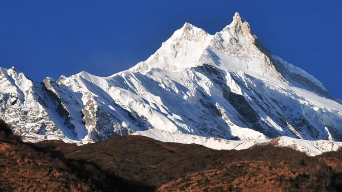
The beautiful scenic views of Annapurna-Manaslu mountain range will spellbind you. This virgin trail passes through the remote landscapes of the Gorkha region. The foothills of the eighth highest mountain in the world, Mt. Manaslu (8163m) provides great adventure.
The trek takes you through the lush alpine forests at lower elevations. You will also get the opportunity to cross the challenging Larkya La Pass (5,213 m) along the trail. The numerous waterfalls, frozen lakes, and pristine water streams are the major attractions of the trek.
The spectacular sunrise from various vantage points along the trail, overlooking the snow-capped mountains is awe-inspiring. Trekking the uncharted landscapes of the Manaslu region is every adventure seeker’s fantasy.
So are you ready to take this awesome trek in the Manaslu region? Read further for relevant information regarding the trek and book your trip now!
Significant Highlights of the Trek:
- Ascending and crossing the majestic Larkya La Pass (5,213 m), which is also the highest point on the trek
- Exploring the virgin landscapes of the Manaslu region
- A cultural exploration of the Gurung, Tamang, and the Tibetan ethnic groups
- Observing the Panoramic Himalayan vista of Manaslu, Annapurna II, Himlung Himal, Gyaji Kang, Nemjung, Cheo Himal, and Kang Guru mountain
- Exquisite sunrise and sunset view along the trail
- Spotting the rare wildlife including the Agali Blue Sheep, snow leopards, Pika, Tahr Mountain Goat, and others
- Incredible hospitality of the Nepalese people
When is the Best Time to Trek the Manaslu Region?
There are basically two trekking seasons in the Manaslu region. The spring months of March-May and autumn months of September-November are the best time for this trek. These months provide the perfect trekking temperatures and spectacular views of the mountains.
✔ Autumn (September-November)
Autumn is the peak trekking season in the Manaslu region. The moderate temperatures aided by stable weather and minimal precipitation is perfect for trekking. The cloudless skies provide spectacular unobstructed mountain views in the autumn season.
The trekking temperatures of 10°C - 15°C in the daytime makes it easy for trekkers. The festive atmosphere complemented by the moderate temperatures adds to the advantages of the trek in the autumn season.
✔ Spring (March-May)
The Manaslu region looks its best in the spring season. The long, warm days with the daytime temperature ranging between 10°C - 20°C is favourable for trekking. The blissful period in the mountains provides us with crystal clear views of the mountains.
The hilly trails turn red and pink as the rhododendron flowers bloom all over the trail. The fresh mountain breeze ensures the clouds turn away resulting in lesser chances of rainfall and overall pleasant trekking experience.
You can also trek the region in the off-season, but that comes with added risks. Summers are generally wet in Nepal. In the monsoons, the incessant rain makes the trails slippery with chances of landslides. The winters, on the other hand, are frigid. However, with proper preparation, Manaslu trek 12 days is doable all round the year.
How Difficult is the 12 days Manaslu Trek?
The “Manaslu Trek 12 days” is moderate in difficulty. The trek is relatively less challenging as compared to other treks in Nepal. However, it also comes with its own sets of challenges. The steep climb of the Larkya La Pass (5,213 m) is quite challenging, especially if it gets covered in snow.
The remoteness of the off the beaten trail also adds to its difficulty level. The cold conditions, especially in the mornings and nights, are a nuisance. The minimal oxygen levels in the high altitude regions can create altitude sickness and other challenges for the trekkers.
The Manaslu trek requires a basic level of fitness. The trail also moves up and down in the rough terrains in the foothills of the Himalayas. You will have to walk for 5-6 hours a day for 11-12 days, that will test your stamina to the core.
Why to Trek the Manaslu Region?
Wonderful Scenic trails
The pristine natural wonders of the Manaslu trek is breathtaking. The scenic trail passes through the emerald lakes and serene waterfalls. We also cross the majestic Larkya La Pass at 5,000m, which is the highest point of the trek. The Manaslu circuit trek boasts of the incredible natural beauty all along the trail.
Off-The-Beaten adventure
Manaslu region is a remote off the beaten trail in Nepal. The Manaslu trails lie within a short distance of the Kathmandu city. The relatively new trail opened in 2010 and has been quite popular among backpackers and solitary travellers.
Many tea houses have sprung up along the trails. Trekkers can enjoy this exciting trail with excellent accommodation facilities. The Manaslu region is less crowded compared to other popular trails including Everest base camp, Annapurna base camp, etc.
Perfect for all skill levels
Manaslu circuit Trek 12 days reaches the maximum height of 5,150m at the Larkya la pass. The trek is safe for hikers that want to trek at a languid pace with regular breaks.
You will have plenty of time to adapt and cope with altitude sickness through the process of acclimatization. The trek is ideal for all skill levels and is relatively safer in comparison to all other treks in Nepal.
Budget trek at a bargain price
Manaslu Circuit Trek is perfect for budget travellers at a reasonable price. The close proximity of the Manaslu region from Kathmandu means that you don’t require an expensive flight ticket like the one from Kathmandu to Lukla for the Everest base camp trek. The accommodation, meals, and other facilities of the Manaslu Trek is available at a bargain price.
Detailed Itinerary of Manaslu Trek 12 Days:
Day 01: Drive from Kathmandu to Soti Khola
Maximum Altitude: Soti Khola (710 m)
Drive duration: 8 hours
Total distance covered: 13 km
Our journey starts with a scenic drive from Kathmandu to Arughat. The 7-9 hours drive takes us through the picturesque landscapes of the hilly region in Nepal. The road is pretty good as we stay on the highway, but starts to get patchy as we reach Gorkha or Dhading.
We rest and have our lunch before we resume our journey from Arughat to Soti Khola. The 13 km journey to Soti Khola provides you with a beautiful view of the Himalayas like Ganesh Himal, Mt. Annapurna, Manaslu range in all directions. We stay overnight at a lodge in Soti Khola.
Day 02: Trek from Soti Khola to Machha Khola
Maximum Altitude: Macha Khola (900 m)
Trek duration: 5 hours
Total distance covered: 15 km
After breakfast, we start our trekking journey from Soti Khola to Machha Khola. The trek is 15km away and takes us 5 hours to arrive there. From Soti Khola, we arrive at an army camp in Lighting and then we arrive at a green chilli field of Khursani baari. The 100m waterfall in the opposite direction of Khursani Baari is spectacular.
We walk on the banks of Machha Khola. You can observe the landslide area caused by the massive earthquake of April 2015. The roads that were severely damaged by the earthquake have been rebuilt. The remote place has scattered settlements with few lodges and hotels in the area. You will stay overnight at a lodge in Machha Khola.
Day 03: Trek from Machha Khola to Jagat
Maximum Altitude: Jagat (1410 m)
Trek duration: 6-7 hours
After breakfast, we start our trek from Macha Khola to Jagat. After completing the necessary formalities in the police checkpoint in Machha Khola, we resume our trek to Jagat. We can enjoy a dip in the hot spring and continue our tail in the steep valley sections.
Around 20 minutes later, we get the horizon view of cantilever bridge from Yaru Bagar. The 158 m long cantilever bridge is the first bridge in Nepal. After 7 hours and covering 22 km of distance we arrive at Jagat. We can observe the vast fields of Jagat where we stay at a lodge overnight.
Day 04: Trek from Jagat to Deng
Maximum Altitude: Deng (1804 m)
Trek duration: 6-7 hours
After breakfast, we start our trek to Deng after a formal checking of the permit in the upper Jagat checkpoint. The walk takes about seven hours to Deng village with few houses. After 40 minutes of walking, we arrive at Salleri, from where we cross the milky white river.
There are a couple of hydro-power plants along the trail. After passing through Salleri, we arrive at Sirdibas inhabited by the Gurung community, the mountain view of Siring (7239m) is of the magnificent view from the place. After a walk of 15 to 20 minutes and crossing a bridge, you will arrive at Philim.
There are many revenue offices, administrative offices, land police stations, and other offices in Philim. After a short hike to Chisapani, we take a break to relieve ourselves and have lunch. We then pass through the settlements of Naykphedi and Pewa for one and a half hours.
In Pewa, we have to cross the stunning suspension bridge twice and arrive at Deng 45 minutes later. We stay overnight at Deng.
Day 05: Trek from Deng to Namrung
Maximum Altitude: Namrung (2630 m)
Trek duration: 6-7 hours
After breakfast, we start our trek to Namrung, which is almost 21 km away from Deng and takes a total of 7 hours. We start our trek to the pristine Budhi Gandaki River and ascent to the Rana gaon overlooking the scenic mountain views. We walk for about 45 minutes to arrive at Bhimphedi.
A further two hours hike will lead you to Ghap where we have our lunch. After lunch, we resume our trek through the dense forest and cross the river and continue the trail passing through the dead pine trees. We arrive at Suksum from where we climb to Namrung after an ascent of almost 1 hour and 20 minutes.
The Tibetan lifestyle and culture of the place will amaze you. In Namrung, you can find a resort that provides luxurious facilities at 35$ US a room with added costs for food. The beautiful views of the Himalchuli Range, Saula Himal are enthralling.
Day 06: Trek from Namrung to Samagaun
Maximum Altitude: Samagaon (3500 m)
Trek duration: 6-7 hours
After breakfast, we start our trek from Namrung to Samagaun, passing through the settlements of Banjam, Lihi, Sho, Lho, and Sayla. You can observe and offer your prayers at one of the oldest monasteries which in Lho.
There are around 200 monks in the monster living and studying in the monastery. The trails to Lihi is steep, and you can observe the alternative perspective of Ganesh Himal, north Himchuli and Naike peak from Lihi.
We continue our trek to Show and arrive at the crossroads our of which one takes us to Hinayang monastery, and the other leads us to Manaslu Larkya pass. It takes around 1 hour 30 minutes to arrive at Lho and 2 hours to arrive at Sayla from Lho. From Sayla, you can observe the panoramic sunrise overlooking the majestic mountains of north Himalchuli and Nadi Chuli Manaslu.
The other visible mountains include Nike peak, north Manaslu, Siringi Himal, Saula Himal. You can also watch the yaks grazing in the vast landscapes. The 200-year-old village is also the biggest in the region. The trade town is a significant hub before we arrive at the the Manaslu Base Camp.
Day 07: Acclimatization Day at Samagaun
Acclimatization is an integral process of the trek. You can explore the area around Samagaon. You can also hike the Birendra Tal which is at a distance of 3 km from Samagaon. You also have an opportunity to walk to the famous Pungen monastery and Basecamp.
The Base Camp trek is 5 hours trek, and it is 6 km away. The base camp lies at an elevation of 4800m. The view of the Manaslu glacier is spectacular, and you will need to cross the glacier to arrive at the Camp area. There are numerous caves in the area as well.
The Pungen monastery, on the other hand, has a flat landscape and provides a panoramic view of the snow-capped mountains. You will return from the hike and stay overnight at Samagaun.
Day 08: Trek from Samagaun to Samdo
Maximum Altitude: Samdo (3800 m)
Trek duration: 4 hours
After breakfast, we hike for 3 hours and climb a steep uphill that takes about 15 minutes and arrive at our destination. The awe-inspiring views of Manaslu, Himchuli, Syaula Peak, Naike Peak, Larke peak and Cho peak will enthral you.
Samdo is a small settlement at the height of 3800m. The micro Hydropower Project provides electricity in the region. The walk is gentle, and you will stay overnight at Samdo.
Day 09: Trek from Samdo to Dharamshala
Maximum Altitude: Dharamsala ( 4450 m)
Trek duration: 4 hours
After breakfast, we start a downhill trek to Budhi Gandaki River. We cross the pristine river at the Larkya Bazaar and Salka Khola to arrive at Dharmasala which provides a place to stay for the night.
The total trekking distance is 7 km and takes about 4 hours. You can also observe a rare sighting of blue sheep if you are lucky. The alternative name for the place is Larkya Phedi. We stay overnight at Dharamsala.
Day 10: Trek from Dharamsala to Bhimtang
Maximum Altitude: Larkya La Pass (5213 m)
Trek duration: 9 hours
We start our trek early in the morning around 3 am to observe the panoramic sunrise overlooking the snow-capped mountains. The mountains include Annapurna II, Himlung Himal, Kang Guru Himal, Cho Himal, Cho and Larke peak, and others.
We will also cross the famous and challenging Larkya La Pass at 5213m which is the highest point of our trek. You can witness the best views of the Himalayan ranges including Annapurna II, Kang Guru, Cho Himal, Himlung Himal, and others.
After successfully crossing the majestic pass, we descend downhill to arrive at a grassy moraine. The trail gets gentle from hereonwards and after a trek almost 9 hours, we arrive at Bhimtang where we stay overnight.
Day 11: Trek from Bhimtang to Dharapani
Maximum Altitude: Dharapani (1860 m)
Trek duration: 7-8 hours
After breakfast, we start our trek to Dharapani from Bhimtang. We pass through the unique settlements of Karche, Goa, Tilche to arrive at Dharapani. The trail then moves downhill to the pristine Dudh Khola famous for its milky liked textured water.
We then move uphill climb before descending through the pine jungle. The trails will get filled with rhododendron and other wildflowers in the months of May and June. We have our lunch after arriving at Surkhi. After lunch, we ascend the trail for about 10 minutes and then descend to Goa. There are few hotels and lodges in Goa.
After walking for 20 minutes, we cross a bridge that leads us to Dharapani after passing through the settlements of Mane and Tiliche. We stay overnight at a lodge in Dharapani.
Day 12: Drive to Kathmandu from Dharapani
Maximum Altitude: Kathmandu (1440 m)
Drive duration: 7-8 hours
After breakfast, we take a jeep drive to Besisahar. From Besisahar, we take a scenic ride on the banks of Marsyangdi River overlooking the small settlements and green hills. We pass through the long winding hilly roads to finally arrive at Kathmandu after a drive of almost 7-8 hours.
✔ If you want to extend trekking days then you can go for 15 Days Manaslu Trek.


